Long Island Index Unveils New Interactive Map, Providing Consumers and Policymakers with Easy-to-Access Information on Long Island and its Communities
Garden City, NY – April 25, 2017 – The Long Island Index, a project of the Rauch Foundation, today launched a new interactive map that enables Long Islanders to access easily an extraordinary array of data about Long Island and its communities. The map – available at www.longislandindexmaps.org – provides a wealth of information about the region, its characteristics, and key indicators – as well as its individual communities and their attributes.
The map enables users to enter the name of a community or a specific street address and have instant access to a range of valuable information. By entering a street address, for instance, a consumer – either a resident or someone interested in moving to the area – can learn about local amenities, nearby schools, the immediate neighborhood, utility service providers, elected officials, and other topics.
The map offers the latest-available data and features cutting-edge mapping tools to help policymakers, community groups, educators, students, the media, and the general public learn about the region and its communities. It relies on the latest web technology, which invites users to interact with the map, enables the map to be displayed on any device including tablets and mobile phones, and renders the map and data quickly. You can simply move your mouse, for instance, over map elements or tap them to display location-specific information.
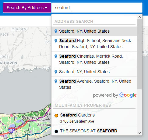
 The map’s geographic search engine displays a single search box to locate villages, landmarks, street addresses, and other data on the map such as schools, multifamily properties, and more. Once a web user clicks in the box (without even typing), a list of options appears automatically. As one starts typing, results based on the text input are displayed (example at right), offering suggestions to the user about how to further customize the search and making it easy to select from the list of possible results.
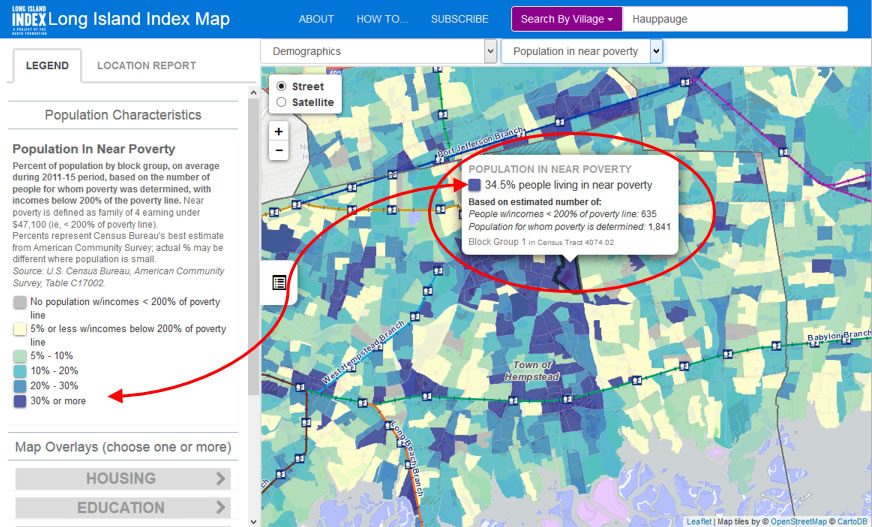
The map also features the latest data from the U.S. Census Bureau’s American Community Survey, showing population estimates by “block group” (small areas within villages or hamlets; see graphic at right) for the 2011-2015 period. This information represents the first local population estimates since the 2010 decennial census. It will continue to be updated leading up to the 2020 census.
 The map includes, among other data, the latest information on school districts and schools throughout Long Island. It provides the only online bird’s-eye-view of multifamily housing across both counties, displaying rental and coop/condo locations in an easy-to-use format. It also includes new data on water monitoring sites in both counties, displaying information compiled by Stony Brook University researchers as a vital indicator of the health of Long Island’s bays and harbors.
“The Long Island Index’s interactive map is an extraordinary resource that puts a wealth of information at the fingertips of Long Islanders,” said Nancy Rauch Douzinas, President of the Rauch Foundation. “It enables us to understand better our region and communities and to have easy access to vital information to inform public discussion and policymaking.”
“The interactive map enables a wide range of audiences to conduct tailored searches on a broad array of topics, as they relate to specific geographic areas of interest,” said Ann Golob, Director of the Long Island Index. “Its accessibility, versatility, and breadth are truly exceptional.”
The Long Island Index’s interactive mapping has been developed in collaboration with the Center for Urban Research at the Graduate Center of the City University of New York. Steven Romalewski, Director of the Graduate Center’s Mapping Service, said, “Long Islanders now have the latest mapping technology at their disposal. It makes current and historical information and trends readily available on specific locations, individual communities, the counties and the region.”
For further information, contact Henry Miller at hmiller@highimpactpartnering.com.
About the Long Island Index
Now in its 14th year, the Long Island Index is a source of unbiased reliable data for businesses, nonprofits, civic organizations, educators, and townships throughout the region. Funded by the Rauch Foundation, its overarching goals are to measure where we are and show trends over time, encourage regional thinking, compare Long Island’s situation with those in similar regions, increase awareness of issues and their interrelatedness, and inspire Long Islanders to work together to achieve shared goals. The Long Island Index reports are available for download at www.longislandindex.org; its interactive maps – an online resource with detailed demographic, residential, transportation and educational information – are also accessible from the Index’s website.
About the Rauch Foundation
The Rauch Foundation (www.rauchfoundation.org) is a Long Island-based family foundation that invests in ideas and organizations that spark and sustain early success in children and systemic change in our communities. The Foundation was established in 1961 by Louis Rauch and Philip Rauch, Jr. Funding for the Foundation was made possible by the success of the Ideal Corporation, an auto parts manufacturer founded in 1913 by their father, Philip Rauch, Sr.
About the Center for Urban Research
The Center for Urban Research (http://www.urbanresearch.org), housed within the Graduate Center of the City University of New York (CUNY), organizes basic research on the critical issues that face New York and other large cities in the United States and abroad. It collaborates on applied research with public agencies, nonprofit organizations and other partners, and holds forums for the media, foundations, community organizations and others about urban research at the Graduate Center and elsewhere across the CUNY system. The CUNY Mapping Service at the Center for Urban Research assists organizations in realizing the geographic and mapping dimensions of their activities.
About the Graduate Center, CUNY
The Graduate Center (GC) is the principal doctorate-granting institution of the City University of New York (CUNY). Positioned at the center of the largest urban public university in America, the GC fosters pioneering research and scholarship in the arts and sciences, and trains graduate students for careers in universities and the private, nonprofit, and government sectors. Unlike typical research-intensive universities, the Graduate Center focuses exclusively on graduate education, with over 35 doctoral and master’s programs, and 30 research centers, institutes and initiatives. Every year, GC students teach over 200,000 CUNY undergraduates, with another 150,000 undergraduates taught by GC alumni in virtually every college and university across the City. Through its public programs, the Graduate Center enhances the City’s intellectual and cultural life. Visit www.gc.cuny.edu to learn more.